Be.Smart Site Management
  • ℹ️What is Be.Smart Site Management?
  • ⚙️Requirements
  • 💾Supported file formats
  • 🆕What's new ?
    • Q1/2023 Release
    • Q2/2023 Release
    • Q3/2023 Release
    • Q1/2024 Release
  • Getting started
    • Project set up in Trimble Connect
      • Create a project to Trimble Connect
        • Create a blank project (Trimble Connect)
        • Create a project based on template
      • User management in Trimble Connect environment
      • Project settings in Trimble Connect
    • Project set up in Autodesk Construction Cloud
      • Create a project to ACC
        • Create a blank project (ACC)
      • User management in ACC environment
    • Project set up in Site Management
      • Site Management - Project configuration
        • Coordinate reference system
        • Project location
        • Toggles
        • Coordinate formatting
        • AIS marine traffic
        • Application background maps
        • Background maps
        • Overlay maps
        • Default background map
        • Default models
        • Project links
        • Connections
        • Permissions and Metadata
      • Settings for Site Management
  • Site Management
    • Project interface
      • Toolbar
      • Project tree
      • Map interface
    • 📐Measurement tool
    • 📈Elevation tool
    • ✂️Section tool
      • How to create a section
      • Measurements in sections
      • Breaklines in section
      • Print tool in a section
    • 🖨️Print tool
      • Print tool options
    • 📏Inspect breaklines
    • ✏️Markings
      • Creating a marking
      • Editing a marking
      • Inspect markings
      • Filtering markings
      • Use-cases for markings
    • 📸Presets
      • Creating a preset
      • Open a preset
    • 🗺️Map layers
    • 🎥3D viewers
  • Integrations and extensions
    • GeoView -integration
    • Pointscene -integration
      • Define the calculation type
      • Select the point cloud
      • Select the LandXML -file
      • Defining the boundary
      • Visualization
      • Results
    • Utilization -extension
      • Utilization report
    • Machine Control -extension
      • Novatron/MOBA Xsite Manage
      • Topcon Sitelink 3D v2
Powered by GitBook
On this page
  1. Getting started
  2. Project set up in Site Management
  3. Site Management - Project configuration

Coordinate formatting

PreviousTogglesNextAIS marine traffic

Site Management displays coordinates in many places in the user interface, some are in full format and others in compact format. The full format is the more common one.

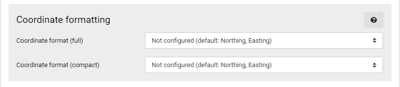
There are six options how the coordinates are displayed, five of these are predefined and one is fully customizable. The bolded option is the default setting.

  • Northing, Easting

  • Easting, Northing

  • Decimal Degrees (WGS 84)

  • Degrees and Decimal Minutes (WGS 84)

  • Degrees, Minutes and Seconds (WGS 84)

  • Custom template

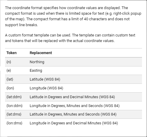
To use the custom template, these are the possible options:

Coordinate formatting